
(Francais) Dash et Dot: Le projet 4 régions de la Californie (3e à 5e année)
Description Les élèves travailleront en groupes de 3 ou 4 pour créer une cartographie en 2D et en 3D d'une région de Californie. Ils devront programmer leur robot afin que celui-ci soit un guide pour

Educational Standards - New Brunswick
Grade 4-6 - Science
Content
Life Science: Habitats
302-1 identify a variety of local and regional habitats and their associated populations of plants and animals
302-2 describe how various animals are able to meet their basic needs in their habitat
Plan and Perform
204-6 identify various methods for finding answers to given questions as well as solutions to given problems, and ultimately select one that is appropriate
STSE (Science Technology Society Environment)
108-6 identify their own and their family’s impact on natural resources
108-3 describe how personal actions help conserve natural resources and care for living things and their habitats
Educational Standards - Alberta
Grade 5 – Science
Wetland Ecosystems
1. Recognize and describe one or more examples of wetland ecosystems found in the local area; e.g., pond, slough, marsh, bog, fen.
2. Understand that a wetland ecosystem involves interactions between living and nonliving things, both in and around the water.
3. Identify some plants and animals found at a wetland site, both in and around the water; and describe the life cycles of these plants and animals.
4. Identify and describe adaptations that make certain plants and animals suited for life in a wetland.
Grade 5 – Social Studies
Physical Geography of Canada
Specific Outcomes
5.1.2 examine, critically, the physical geography of Canada by exploring and reflecting upon the following questions and issues:
Skills and Processes
- generate original ideas and strategies in situations of individual and group activities
- seek responses to inquiries from various authorities through electronic media
- recognize that information serves different purposes and that data from electronic sources may need to be verified to determine accuracy or relevance for the purpose used
- use latitude and longitude to determine the absolute location of places in Canada on maps and globes
- construct maps, diagrams and charts to display geographic information
- use cardinal and intermediate directions and simple grids to locate places on maps and globes
- use the scale on maps and globes to determine the distance between places
- access and retrieve appropriate information from the Internet by using a specific search path or from given uniform resource locators (URLs)
- navigate within a document, compact disc or other software program that contains links
- organize information gathered from the Internet, or an electronic source, by selecting and
recording the data in logical files or categories
- listen to others to understand their perspectives
- create visual images for particular audiences and purposes
Grade 5 – ELA
2.4 Create Original Text
use texts from listening, reading and viewing experiences as models for producing own oral, print and other media texts
3.2 Select and Process
locate information to answer research questions, using a variety of sources, such as newspapers, encyclopedias, CDROMs, a series by the same writer, scripts, diaries, autobiographies, interviews and oral traditions
Grade 5 (Division 2) - Information and Communication Technology
Foundational Operations, Knowledge and Concepts
F1 - 2.1 apply terminology appropriate to the technologies being used at this division level
F3 - 2.2 work collaboratively to share limited resources
F3 - 2.3 use appropriate communication language and etiquette
F6 - 2.1 power up and power down various technologies and peripherals correctly
F6 - 2.3 use peripherals, including printers and scanners
Educational Standards - British Columbia
Grade 3 – Science
Content
- biodiversity in the local environment
- major local landforms
Curricular Competencies
- Suggest ways to plan and conduct an inquiry to find answers to their questions
- Collect simple data
- Represent and communicate ideas and findings in a variety of ways, such as diagrams and simple reports, using digital technologies as appropriate
Grade 3 – ELA
Content
- reading strategies
- writing processes
- sentence structure
Curricular Competencies
- Read fluently at grade level
- Make connections between ideas from a variety of sources and prior knowledge to build understanding
- Use developmentally appropriate reading, listening, and viewing strategies to make meaning
- Exchange ideas and perspectives to build shared understanding
- Communicate using sentences and most conventions of Canadian spelling, grammar, and punctuation
Grade K-3 - Applied Design, Skills and Technologies
Content
Students are expected to use the learning standards
for Curricular Competencies from Applied Design,
Skills, and Technologies K–3 in combination with
grade-level content from other areas of learning in
cross-curricular activities to develop foundational
mindsets and skills in design thinking and making.
Curricular Competencies
• Use materials, tools, and technologies in a safe manner in both physical and digital environments
• Develop their skills and add new ones through play and collaborative work
• Explore the use of simple, available tools and technologies to extend their capabilities
Educational Standards - Ontario
Grade 4 – Science
Habitats and Communities
1.1 analyse the positive and negative impacts of human interactions with natural habitats and communities (e.g., human dependence on natural materials), taking different perspectives into account (e.g., the perspectives of a housing developer, a family in need of housing, an ecologist), and evaluate ways of minimizing the negative impacts
2.3 use scientific inquiry/research skills to investigate ways in which plants and animals in a community depend on features of their habitat to meet important needs (e.g., beavers use water for shelter [they build their lodges so the entrance is under water], food [cattails, water lilies, and other aquatic plants], and protection [they slap their tails on the water to warn of danger])
2.5 use appropriate science and technology vocabulary, including habitat, population, community, adaptation, and food chain, in oral and written communication
2.6 use a variety of forms (e.g., oral, written, graphic, multimedia) to communicate with different audiences and for a variety of purposes (e.g., use presentation software to show the steps one might follow to set up and maintain a terrarium)
3.3 identify factors (e.g., availability of water or food, amount of light, type of weather) that affect the ability of plants and animals to survive in a specific habitat
3.10 describe ways in which humans are dependent on natural habitats and communities (e.g., for water, medicine, flood control in wetlands, leisure activities)
Grade 4 – Social Studies
PEOPLE AND ENVIRONMENTS: POLITICAL AND PHYSICAL REGIONS OF CANADA
B1.1 analyse some of the general ways in which the natural environment of regions in Canada has affected the development of industry (e.g., how the characteristics of the Canadian Shield made possible the development of mining and smelting, forestry, fresh water fisheries, pulp and paper; how the characteristics of the Maritime provinces made possible the development of fisheries, coal mining, agriculture, off-shore oil drilling; how the topography and climate of the Prairies make the region suitable for large-scale farming and ranching)
B1.2 assess aspects of the environmental impact of different industries in two or more physical and/or political regions of Canada (e.g., hydroelectric development in Quebec, the development of the oil sands in northern Alberta, fishing in Atlantic Canada, steel production in Nova Scotia, forestry and fishing in British Columbia, coal-powered electrical plants in Ontario, smelting in northern Ontario, shipping in the Great Lakes–St. Lawrence region)
B2.3 analyse and construct print and/or digital maps, including thematic maps, as part of their investigations into balancing human needs/ wants and activities with environmental stewardship in Canada (e.g., analyse population settlement maps; construct natural resource maps, using symbols to represent different resources; construct physical region maps, using shading to represent elevation change)
B3.1 identify various physical regions in Canada (e.g., landform, vegetation, and climatic regions), and describe their location and some of the major ways in which they are distinct from and similar to each other (e.g., the location of the Western Cordillera and the Appalachian regions and the characteristics of the mountains in each region; characteristics of boreal forest and tundra regions; similarities and differences between agricultural areas in the Niagara region, the Annapolis Valley, and the western plains; climatic differences between the rainforest of Vancouver Island and arid areas such as the Canadian badlands)
B3.2 identify some of the main human activities, including industrial development and recreational activities, in various physical regions of Canada (e.g., large-scale farming in the plains and lowlands; mining and smelting in the Canadian Shield; cattle ranching in grasslands and plains; development of transportation routes along rivers and in valleys and mountain passes; fisheries in oceans, lakes, and rivers; skiing in mountain regions; boating on waterways; hiking on forest or coastal trails)
Grade 4 – ELA
Writing
1.2 generate ideas about a potential topic using a variety of strategies and resources (e.g., brainstorm; formulate and ask questions to identify personal experiences, prior knowledge, and information needs)
1.3 gather information to support ideas for writing using a variety of strategies and oral, print, and electronic sources (e.g., identify key words to help narrow their searches; cluster ideas; develop a plan for locating information; scan texts for specific information, including teacher readalouds, mentor texts, reference texts, shared-, guided-, and independent-reading texts, and media texts)
Leçon
Aperçu et préparation
Description
Les élèves travailleront en groupes de 3 ou 4 pour créer une cartographie en 2D et en 3D d'une région de Californie. Ils devront programmer leur robot afin que celui-ci soit un guide pour explorer la région en donnant des renseignements importants relatifs à la flore de la région, à sa faune, à sa géographie et à ses principales industries.
Objectifs
-
Effectuer des recherches en collaboration et créer une cartographie de la région
-
Enregistrer les données importantes relatives à la flore de la région, sa faune, sa géographie et ses principales industries
-
Exprimer sa créativité en dessinant et créant des éléments 3D sur la carte
-
Programmer Dash à animer une visite guidée de la région en se déplaçant, ainsi qu'avec des éléments sonores et lumineux
Robotique et accessoires

Autres accessoires
- papier quadrillé
- 2 crayons
- carton pour affiche
- 2 règles indiquant les cm
- marqueurs
- ruban cache ou adhésif
- papier de bricolage
- Tablettes - (liste des appareils compatibles)
Classe 1 - Recherche (~60 min)
Les élèves sont répartis en groupes de 3 ou 4. Chaque membre du groupe deviendra spécialiste de la flore et de la faune de la région choisie, de sa géographie et de ses principales industries. Ils utiliseront leurs iPads ou leur manuel de géographie pour effectuer leur recherche. Ils devront écrire une phrase complète à propos d'une caractéristique de la région qu'ils partageront avec les autres.
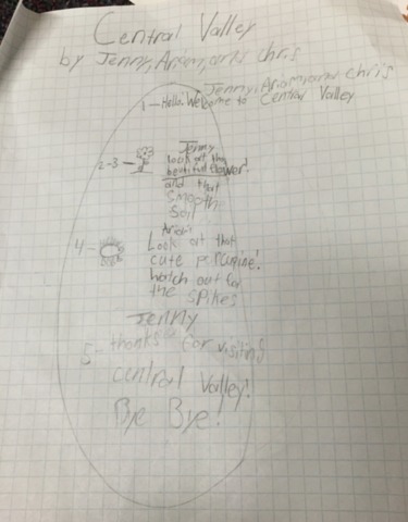
Sur papier quadrillé, les élèves dessineront une carte schématique de leur région. Ils doivent identifier 5 lieux dans la région où ils souhaitent que Dash s'arrête.
Classe 2 - Diriger Dash (~60 min)
Utiliser l'outil Google Slides Presentation pour expliquer comment travailler avec Dash et ce que contient un robot.
Les élèves utiliseront l'application Blocky avec l'iPad pour participer à l'école de conduite Dash.
Un numéro sera attribué à chaque robot Dash afin que les groupes puissent se brancher au robot qui leur est attribué.
Tous les élèves travailleront avec les puzzles au niveau 1 de l'école de conduite, mais certains pourraient être en mesure de débuter au niveau 1.
Classe 3 - Cartographie (~60 min)
Les élèves créent la carte de leur région sur un carton pour affiche. Rappeler aux élèves que Dash ne peut se déplacer que par segments de 10 cm.
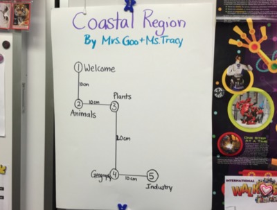
Demander aux élèves de mesurer sur leur carte les distances entre les 5 lieux où il doit s'arrêter et de noter chacune des distances en centimètres.
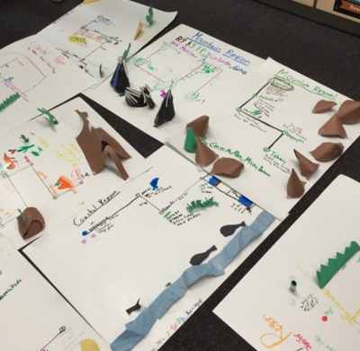
Les élèves doivent ensuite illustrer leur carte et y ajouter des éléments en 3D qu'ils construiront avec le papier de bricolage et le ruban cache ou adhésif.
Classe 4 - Programmation (~60 min)
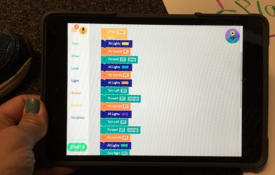
Les élèves utiliseront l'application Blockly pour programmer Dash afin qu'il présente leur région aux autres élèves de la classe.
Rappeler aux élèves qu'ils doivent prévoir 5 lieux de leur région pour présenter sa flore, sa faune, sa géographie et ses industries.
Les élèves doivent également travailler en équipe pour ajouter des éléments créatifs en utilisant les sons, les lumières, l'apparence et les actions de Dash.
Classe 5 - Activités complémentaires
Les élèves présenteront la visite guidée de leur région à toute la classe.
Comme activité complémentaire en mathématiques, les élèves peuvent mesurer la distance (en cm) parcourue par Dash durant la visite guidée de la région.
Les élèves peuvent également inventer une histoire relatant les aventures de Dash dans la région.